Sierra Nevada Snowpack Lowest in 500 Years
Sierra Nevada Snowpack Lowest in 500 Years

Reprint
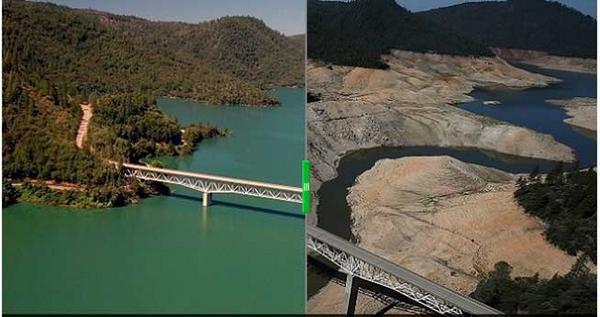
The Sierra Nevada snowpack that is a critical water source for California fell to a 500-year low last winter – far worse than scientists had estimated and underlining the severity of the current drought, according to new research.
“Our study really points to the extreme character of the 2014-15 winter”.
“We should be prepared for this type of snow drought to occur much more frequently because of rising temperatures”, lead author Valerie Trouet, a professor at the University of Arizona, said in a statement.
“Temperatures in California and worldwide will continue to rise, and the chance of low precipitation events co-occurring with high temperatures will increase”, she says. And, while many in the state are hopeful that El Niño will bring some drought relief, the climate phenomenon is unlikely to fall north enough to bring relief to the range.
When the team looked at blue oak tree rings, the drier years showed up when the tree rings were narrower. This is not just unprecedented over 80 years – it’s unprecedented over 500 years.
But for the first time since 1942, when scientists began measuring the state’s snowpack, there was no snow to be found. In fact, throughout the whole range – running about 400 miles down the state’s eastern side – the snowpack was only five percent of its historical average, the lowest ever recorded by a full 20 percent. In a winter with less snow or with winter precipitation coming as rain rather than snow, there is less water to use during California’s dry summers.
Deeper analysis revealed that in 2015, the Tuolumne River Basin in the Sierras contained just 40% as much water in the form of ice and snow as it did when the region’s snowpack levels were highest in 2014. Water managers in California are scrambling to figure out a way to best store the winter rain so it lasts during the dry season.
Hydrologists at the U.S. Department of Agriculture declared the snowpack across the West “gone” back in May, with smatterings left in parts of Colorado, Montana and southern Wyoming. The red lines are where the instrument-recorded data correlates with the tree-ring estimates. “To my mind, I think it’s a fairly robust reconstruction”, says Peter Brown, a dendrochronologist and the director of Rocky Mountain Tree-Ring Research in Fort Collins, Colorado. The historically low snowpack was likely exacerbated by California’s drought and the record-high temperatures over the past year.
The study was published in the journal Nature Climate Change. What’s more, they could calibrate their model by looking at the actual snowpack levels at 108 Sierra Nevada snow stations since the 1930s and comparing them directly to growth rings on those same years on blue oaks. The measurements all confirm what is happening.
The team’s next step, she said, is investigating and reconstructing the atmospheric circulation patterns that contribute to the California drought and the Sierra Nevada snowpack.
Extreme Weather in California